

SCCF preserve map features public trails
The Sanibel-Captiva Conservation Foundation (SCCF) reported that it owns more than 1,900 acres across Sanibel, Captiva and the surrounding watershed, and it protects and also manages an additional 300-plus acres of preserve lands.
Most of the lands are closed to the public to safeguard sensitive ecosystems and wildlife. From habitats that support rare and endangered species to fragile ecological zones, the protected areas play a critical role in sustaining the islands’ unique plants and animals.
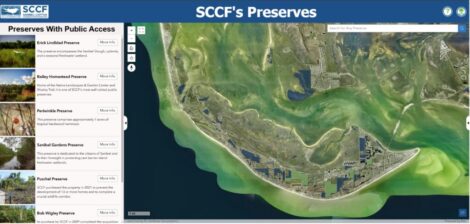
The SCCF also maintains seven preserves that are open for public enjoyment. Spanning iconic wetlands and upland hammocks, these areas feature trails that showcase the islands’ diverse habitats.
To make it easier to explore these places, it has launched a new interactive preserve map. The tool will help visitors locate open preserves, while also raising awareness about those that remain closed for conservation purposes.
Each preserve listing includes key details, such as its status (open or closed), year of acquisition, size, previous ownership and the type of ecosystem it protects. Users can also filter the map by acquisition timeframe or ecosystem type, making it easier to explore and better understand the SCCF’s conservation efforts.
For the best experience, viewing is recommended on a device with a larger screen, such as a computer or tablet. While it is accessible on mobile devices, some features will be limited due to screen size.
To access the preserve map, visit https://sccf.org/what-we-do/preserve-the-land/preserves/?utm_source=chatgpt.com.
To reach SANIBEL-CAPTIVA CONSERVATION FOUNDATION, please email